PROJECT OVERVIEW |
GOALS |
|
There is a narrative that is prevalent in US historical discourse that when Europeans arrived in what they called the “new world” they found a “terra nullius” (an empty land). The narrative continues to say that Spanish, French, British, and later US-American “explorers” set out across the land and “discovered” it.
Sonoran Desert Journeys refutes the narratives of “terra nullius” and “discovery” using maps that visualize O’odham communities, water sources and routes of travel that existed long before Europeans were even aware of the existence of the land that we now call the United States and Mexico. There is a second, more recent, narrative that promotes borders as natural, impermeable and never changing phenomena. The project also refutes this narrative by showing how the US/Mexico border has sliced through O’odham land, how it has moved and changed over time, and highlighting the social and economic connections between people and communities in the Sonoran Desert on both sides of the current location of the US/Mexico border. Sonoran Desert Journeys also maps the historical and present-day erasure of communities, environmental resources, language and culture by the architecture of colonization and militarization on O'odham land at the US/Mexico border. |
The primary target audiences for the project are residents and visitors to the Sonoran Desert and volunteers working with various groups whose practice of humanitarian aid takes place on O’odham land.
Project goals include:
|
SONORAN DESERT JOURNEYS MAP
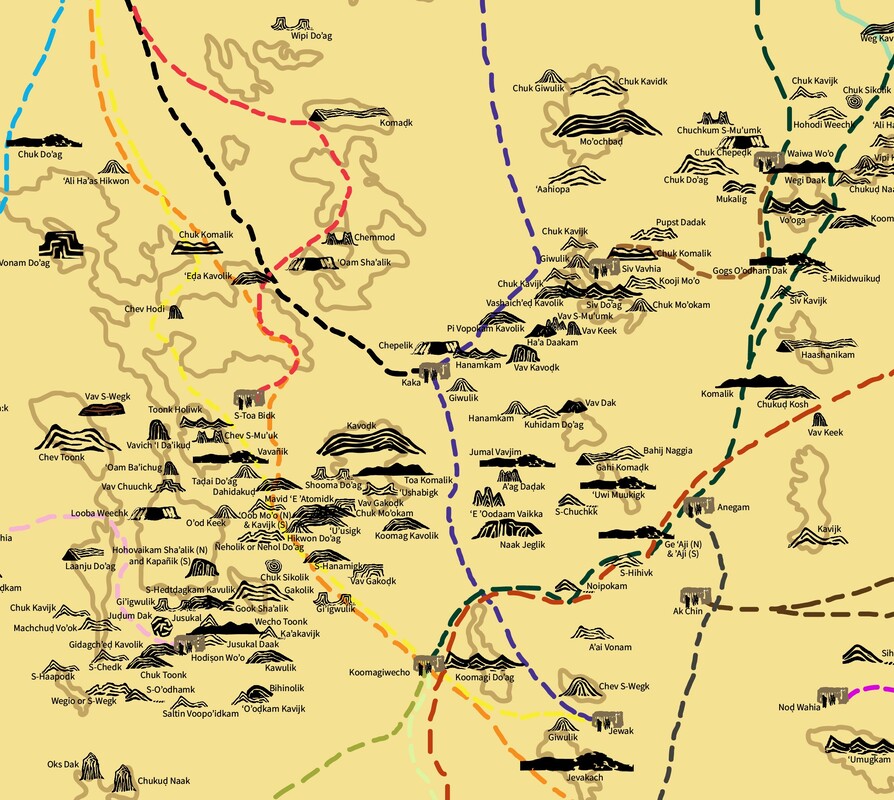
Detail from Sonoran Desert Journeys Map presented at the 2022 Tri-National Sonoran Desert Symposium. CLICK HERE to view the full map.
MAP LEGEND and CREATING ICONS
|
This is the conventional map icon for a mountain. The mountains on O'odham land in the Sonoran Desert are rarely triangular or snowcapped.
|

This icon represents mountains that are "giwulk," that is their shape is giwul (drawn in or molded at the base). Mountains that are giwulk may taper to the top or rise straight up to a flat or jagged top.
|

This icon represents Vaupa S-Mu'umk, that is multiple sharp bedrock peaks (vaupa) separated by small gaps or passes.
|
Designing icons that reflect the land AND are easy to view and understand on the map is a challenge. Some of the icons on the maps are more effective than others. Sonoran Desert Journeys seeks to engage O'odham and non-O'odham border residents in creating an iconography that fulfills both needs .
CLICK HERE to view more icons
CLICK HERE to view more icons
RESOURCES
CLICK HERE to view the current full dataset of place names of mountain, community, water source and other geographical and man-made features. Please note that data collection is an ongoing process. This link will be updated monthly.
CLICK HERE to view a current list of research sources.
CLICK HERE for an introduction to the Alvarez/Hale orthography of the O'odham language, O’Odham Ñiokĭ O’ohana
CLICK HERE to view a current list of research sources.
CLICK HERE for an introduction to the Alvarez/Hale orthography of the O'odham language, O’Odham Ñiokĭ O’ohana
MAP of PLACE NAMES on TOHONO O'ODHAM, AKIMEL O'ODHAM and HIA C'ED O'ODHAM LAND
COLLABORATION
If you are interested in collaborating on research, icon design, photography, editing, funding or something else please CLICK HERE to contact me.